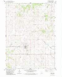
1983 Map of Murray
USGS Topo · Published 1983About this map
Murray anchors this southwestern Iowa landscape, situated at a vital junction of rail and road infrastructure in Clarke County. The Burlington Northern Railroad bisects the town, following the natural ridges that divide the region's many drainages. This high ground serves as the headwaters for several regional waterways, including Sevenmile Creek to the west and White Breast Creek to the southeast. The local topography is defined by these branching creek systems, which have carved distinct valleys across the townships of Madison, Washington, Troy, and Ward. Outside the residential core of Murray, the land is marked by utility and community landmarks like the Murray Cem, a local Substation, and a Radio Tower, reflecting the mid-20th-century development of this agricultural hub.
Find a feature on this map
17 named features on this map. Tap any name to fly to it.
Don’t see what you’re looking for? This feature index may not catch every label — zoom into the map to look around manually.
Map Details
Editions of this 1983 Murray Map
This is the sole edition of this map. No revisions or reprints were ever made.
Other maps of this area

1951 · Osceola
USGS Topo · 1:62,500

1951 · Afton
USGS Topo · 1:62,500

1954 · Centerville
USGS Topo · 1:250,000

1954 · Omaha
USGS Topo · 1:250,000

1954 · Des Moines
USGS Topo · 1:250,000

1955 · Nebraska City
USGS Topo · 1:250,000

1956 · Des Moines
USGS Topo · 1:250,000

1957 · Des Moines
USGS Topo · 1:250,000

1957 · Nebraska City
USGS Topo · 1:250,000

1957 · Omaha
USGS Topo · 1:250,000