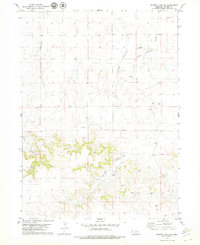
1979 Map of Murray Lake SW
USGS Topo · Published 1979About this map
Warner Ranch and other family-held homesteads anchor this 1970s landscape in Banner County, where the High Plains topography is defined by deep drainage systems. The intricate branching of Bull Canyon and Long Canyon dominates the terrain, illustrating the erosional patterns of the Nebraska panhandle. This era shows a transition in land use, where traditional ranching at Wynne Ranch and Patton Ranch exists alongside specialized infrastructure like the Anderson Landing Strip. Resource extraction is evident through scattered Oil Well locations, Drill Hole sites, and a Gravel Pit, signaling the industrial interests of the period. Sparse water sources, such as the Clay Springs Draw and a lone Spring, remain critical landmarks in this semi-arid environment.
Find a feature on this map
13 named features on this map. Tap any name to fly to it.
Don’t see what you’re looking for? This feature index may not catch every label — zoom into the map to look around manually.
Map Details
Editions of this 1979 Murray Lake SW Map
This is the sole edition of this map. No revisions or reprints were ever made.
Other maps of this area

1898 · Scotts Bluff
USGS Topo · 1:125,000

1899 · Goshen Hole
USGS Topo · 1:125,000

1954 · Scottsbluff
USGS Topo · 1:250,000

1954 · Cheyenne
USGS Topo · 1:250,000

1958 · Cheyenne
USGS Topo · 1:250,000

1958 · Scottsbluff
USGS Topo · 1:250,000

1960 · Tremain
USGS Topo · 1:24,000

1960 · Mc Compsey Pass
USGS Topo · 1:24,000

1960 · Murray Lake
USGS Topo · 1:24,000

1973 · Kimball 2 NE
USGS Topo · 1:24,000