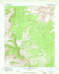
1968 Map of Music Mountains NE
USGS Topo · Published 1972About this map
The Hualapai Indian Reservation dominates the high-desert landscape of this 1968 survey, where the dramatic elevation drops of the Grand Wash Cliffs meet the Music Mountains. This territory is defined by its water management, evidenced by numerous livestock watering points scattered across the plateau such as Black Canyon Tank, Jamison Tank, and Company Tank. These features suggest a landscape primary used for grazing during the mid-20th century, with activity concentrated around these vital reliable water sources.
Find a feature on this map
15 named features on this map. Tap any name to fly to it.
Don’t see what you’re looking for? This feature index may not catch every label — zoom into the map to look around manually.
Map Details
Editions of this 1968 Music Mountains NE Map
2 editions found
Other maps of this area

1886 · Diamond Creek
USGS Topo · 1:250,000

1892 · Diamond Creek
USGS Topo · 1:250,000

1948 · Williams
USGS Topo · 1:250,000

1954 · Williams
USGS Topo · 1:250,000

1956 · Williams
USGS Topo · 1:250,000

1960 · Williams
USGS Topo · 1:250,000

1961 · Williams
USGS Topo · 1:250,000

1967 · Milkweed Canyon SW
USGS Topo · 1:24,000
1967 · Milkweed Canyon NW
USGS Topo · 1:24,000
1967 · Spencer Canyon
USGS Topo · 1:24,000