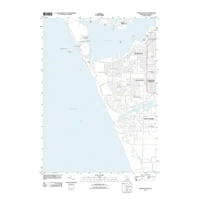
2011 Map of Muskegon West
USGS Topo · Published 2011About this map
Muskegon Lake dominates this coastal landscape, serving as a deep-water harbor protected by the North Breakwater Light and South Breakwater Light. In Muskegon and its southern neighbors, the grid of residential streets is punctuated by significant local landmarks, including the Milwaukee Clipper Dock and several historic burial grounds such as the Indian Cemetery and Lakeside Cemetery. The map captures the industrial and maritime heritage of the eastern shore of Lake Michigan, where maritime navigation aids like Hartshorn Light and Bank Point Light line the approach to the inner harbor. Further south, the suburban expansion of Roosevelt Park and Norton Shores transitions toward Mona Lake, while the Muskegon County Airport occupies the southern reaches of the quadrangle. This detailed topographical study illustrates the integration of recreation at the Muskegon State Park Channel Campground with the essential infrastructure of a Great Lakes port city.
Find a feature on this map
82 named features on this map. Tap any name to fly to it.
Don’t see what you’re looking for? This feature index may not catch every label — zoom into the map to look around manually.
Map Details
Editions of this 2011 Muskegon West Map
This is the sole edition of this map. No revisions or reprints were ever made.
Other maps of this area

1929 · Montague
USGS Topo · 1:48,000

1930 · Lake Harbor
USGS Topo · 1:48,000

1930 · Muskegon
USGS Topo · 1:62,500

1936 · Muskegon
USGS Topo · 1:62,500

1936 · Lake Harbor
USGS Topo · 1:62,500

1954 · Milwaukee
USGS Topo · 1:250,000

1958 · Milwaukee
USGS Topo · 1:250,000

1958 · Twin Lake
USGS Topo · 1:62,500

1959 · Montague
USGS Topo · 1:62,500
1972 · Muskegon West
USGS Topo · 1:24,000