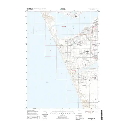
2014 Map of Muskegon West
USGS Topo · Published 2014About this map
Muskegon Lake and Lake Michigan define the character of this West Michigan coastline, where the industrial city and its suburban neighbors meet the dunes. The map highlights a complex hydrographic system including Bear Lake, Ruddiman Lagoon, and Mona Lake, which shape the residential layouts of North Muskegon, Roosevelt Park, and Norton Shores. A notable topographical feature is Pigeon Hill, standing near the channel entrance to the harbor. The settlement pattern shows a dense grid in the core of Muskegon and Muskegon Heights, transitioning to more winding suburban developments along the lakefronts. Cultural and genealogical sites of interest include Marys Cem, the Saint Paul's Episcopal Church Columbarium, and the unique Saint Gregory's Episcopal Church Courtyard Cem. To the south, the Muskegon County Airport and the drainage of Little Black Cr into Little Black Lake mark the edge of the urbanized area.
Find a feature on this map
166 named features on this map. Tap any name to fly to it.
Don’t see what you’re looking for? This feature index may not catch every label — zoom into the map to look around manually.
Map Details
Editions of this 2014 Muskegon West Map
This is the sole edition of this map. No revisions or reprints were ever made.
Other maps of this area

1929 · Montague
USGS Topo · 1:48,000

1930 · Lake Harbor
USGS Topo · 1:48,000

1930 · Muskegon
USGS Topo · 1:62,500

1936 · Muskegon
USGS Topo · 1:62,500

1936 · Lake Harbor
USGS Topo · 1:62,500

1954 · Milwaukee
USGS Topo · 1:250,000

1958 · Milwaukee
USGS Topo · 1:250,000

1958 · Twin Lake
USGS Topo · 1:62,500

1959 · Montague
USGS Topo · 1:62,500
1972 · Muskegon West
USGS Topo · 1:24,000