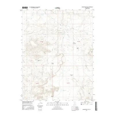
2017 Map of Mussentuchit Flat
USGS Topo · Published 2017About this map
Mussentuchit Flat defines this desert landscape in Emery County, characterized by a series of high ridges and a sophisticated water management network of small catchments and reservoirs. The area's hydrology is marked by the seasonal drainage of Willow Springs Wash and Mussentuchit Wash, which feed into numerous livestock and agricultural catchments like Mussentuchit Reservoir, Wests Reservoir, and Sand Rock Reservoir. The terrain is punctuated by prominent landmarks such as Deadman Peak and the high vantage of Cedar Mtn. Transportation through this arid basin relies on a grid of county roads including Co RD 912 and the winding Lower Last Chance Loop, illustrating the remote but deliberate infrastructure developed to manage and access the diverse resources of the San Rafael Swell's western reaches.
Find a feature on this map
28 named features on this map. Tap any name to fly to it.
Don’t see what you’re looking for? This feature index may not catch every label — zoom into the map to look around manually.
Map Details
Editions of this 2017 Mussentuchit Flat Map
This is the sole edition of this map. No revisions or reprints were ever made.
Other maps of this area

1885 · Fish Lake
USGS Topo · 1:250,000

1896 · Fish Lake
USGS Topo · 1:250,000

1925 · Acord Lakes
USGS Topo · 1:62,500

1953 · Emery 4 NE
USGS Topo · 1:24,000

1953 · Emery 4 SE
USGS Topo · 1:24,000

1953 · Emery 1 SE
USGS Topo · 1:24,000

1956 · Salina
USGS Topo · 1:250,000

1960 · Salina
USGS Topo · 1:250,000

1962 · Salina
USGS Topo · 1:250,000
1968 · Solomons Temple
USGS Topo · 1:24,000