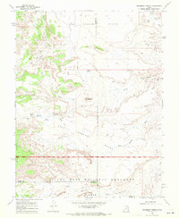
1968 Map of Solomons Temple
USGS Topo · Published 1972About this map
Capitol Reef National Monument anchors the southern boundary of this high-desert survey, where the Sevier, Emery, and Wayne county lines converge. The landscape is defined by its arid drainage systems, including the long course of Last Chance Creek and the intricate carving of Temple Wash. Significant landmarks such as Solomons Temple and the flat expanse of Jones Bench rise above the basin floor, illustrating the complex erosion patterns characteristic of the San Rafael Swell's southern reaches. Human activity is sparse but evident in the vital water sources like Birch Spring and the artificial Jeffery Reservoir, which sustained local livestock and travelers during the late 1960s. A network of Jeep Trails provides the primary access through this remote terrain, connecting the drainage of Rock Springs Wash to the broader Last Chance Desert.
Find a feature on this map
18 named features on this map. Tap any name to fly to it.
Don’t see what you’re looking for? This feature index may not catch every label — zoom into the map to look around manually.
Map Details
Editions of this 1968 Solomons Temple Map
2 editions found
Other maps of this area

1885 · Fish Lake
USGS Topo · 1:250,000

1896 · Fish Lake
USGS Topo · 1:250,000

1922 · Emery No.3
USGS Topo · 1:31,680

1952 · Notom 2 NW
USGS Topo · 1:24,000

1952 · Notom 2 NE
USGS Topo · 1:24,000

1952 · Torrey
USGS Topo · 1:62,500

1954 · Fruita
USGS Topo · 1:62,500
1954 · Notom 1 NW
USGS Topo · 1:24,000

1956 · Salina
USGS Topo · 1:250,000

1960 · Salina
USGS Topo · 1:250,000