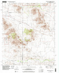
1996 Map of Mustang Mountains
USGS Topo · Published 2002About this map
San Ignacio Del Babocomari defines the southern reach of this landscape, where the Babocomari River flows through a valley anchored by historic ranching operations. The map documents a transition between the high peaks of the Mustang Mountains and the grazing lands of Rain Valley, highlighting a rural economy built around water sources like Cottonwood Spring and T'i Springs. Large landholdings such as Sands Ranch, Babocomari Ranch, and Rain Valley Ranch indicate a pattern of expansive open-range territory.
Find a feature on this map
29 named features on this map. Tap any name to fly to it.
Don’t see what you’re looking for? This feature index may not catch every label — zoom into the map to look around manually.
Map Details
Editions of this 1996 Mustang Mountains Map
This is the sole edition of this map. No revisions or reprints were ever made.
Other maps of this area

1904 · Patagonia
USGS Topo · 1:125,000

1905 · Patagonia
USGS Topo · 1:125,000

1915 · Benson
USGS Topo · 1:125,000

1926 · Whetstone
USGS Topo · 1:62,500

1932 · Elgin
USGS Topo · 1:62,500

1938 · Huachuca
USGS Topo · 1:62,500

1940 · Elgin
USGS Topo · 1:62,500

1943 · Benson
USGS Topo · 1:125,000

1947 · Elgin
USGS Topo · 1:62,500

1948 · Elgin
USGS Topo · 1:24,000