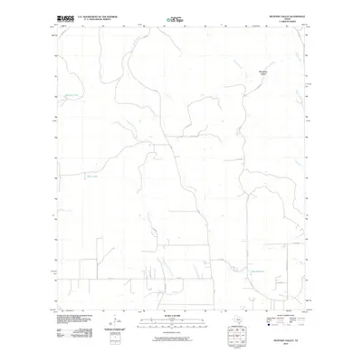
2010 Map of Mustang Valley
USGS Topo · Published 2010About this map
Mustang Valley and its surrounding ranchland characterize this portion of Medina County, where the landscape is defined by a network of seasonal watercourses and drainage systems. The presence of King Waterhole along the southern reaches of the map suggests a local history tied to dependable water sources in a region dominated by ephemeral streams. Water management for livestock is evident through features like Mustang Tank and Black Tank, reflecting the area's continued agricultural and pastoral identity. This 2010 survey shows a sparse settlement pattern connected by a grid of county roads and the primary north-south artery of FM 462. Significant drainages including Hondo Creek, Mustang Creek, and the East Branch Live Oak Creek carve through the terrain, illustrating the natural watershed that has long dictated the placement of roads and homesteads in this rural Texas environment.
Find a feature on this map
26 named features on this map. Tap any name to fly to it.
Don’t see what you’re looking for? This feature index may not catch every label — zoom into the map to look around manually.
Map Details
Editions of this 2010 Mustang Valley Map
This is the sole edition of this map. No revisions or reprints were ever made.
Other maps of this area

1954 · San Antonio
USGS Topo · 1:250,000

1956 · Sabinal
USGS Topo · 1:62,500

1956 · New Fountain
USGS Topo · 1:62,500

1956 · Tarpley
USGS Topo · 1:62,500

1956 · Bandera
USGS Topo · 1:62,500

1957 · San Antonio
USGS Topo · 1:250,000

1964 · Timber Creek
USGS Topo · 1:24,000
1969 · Twin Hollow
USGS Topo · 1:24,000
1969 · Texas Mountain
USGS Topo · 1:24,000

1969 · Sabinal NE
USGS Topo · 1:24,000