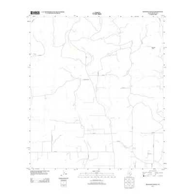
2012 Map of Mustang Valley
USGS Topo · Published 2012About this map
Mustang Valley in Medina County is defined by a dendritic network of seasonal creek beds and drainage draws characteristic of the Texas Hill Country. The landscape is dominated by the winding courses of Hondo Cr, Mustang Cr, and E Br Live Oak Cr, which converge as they move toward the southern plains. Human imprint on this rural terrain is marked by a grid of county roads and water management features such as Mustang Tank, Black Tank, and the notably named King Waterhole along the southeastern reaches of Hondo Cr. These water sources were essential for the cattle ranching operations that have long anchored the local economy. The transition from the more topographically varied north to the flatter agricultural lands in the south is reflected in the straightening of the road network, including FM-462 and numerous numbered county routes.
Find a feature on this map
28 named features on this map. Tap any name to fly to it.
Don’t see what you’re looking for? This feature index may not catch every label — zoom into the map to look around manually.
Map Details
Editions of this 2012 Mustang Valley Map
This is the sole edition of this map. No revisions or reprints were ever made.
Other maps of this area

1954 · San Antonio
USGS Topo · 1:250,000

1956 · Sabinal
USGS Topo · 1:62,500

1956 · New Fountain
USGS Topo · 1:62,500

1956 · Tarpley
USGS Topo · 1:62,500

1956 · Bandera
USGS Topo · 1:62,500

1957 · San Antonio
USGS Topo · 1:250,000

1964 · Timber Creek
USGS Topo · 1:24,000
1969 · Twin Hollow
USGS Topo · 1:24,000
1969 · Texas Mountain
USGS Topo · 1:24,000

1969 · Sabinal NE
USGS Topo · 1:24,000