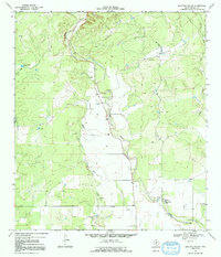
1969 Map of Mustang Valley
USGS Topo · Published 1992About this map
Mustang Valley defines this portion of the Texas Hill Country, where the landscape is carved by a network of seasonal watercourses and drainage basins. Surveyed in the late 1960s, the map reveals a rural economy centered on water management and resource extraction, characterized by numerous Gravel Pits and isolated water sources like Mustang Tank and Black Tank. The perennial flow of Hondo Creek serves as the primary geographic anchor, featuring the notable King Waterhole and a Gaging Sta to monitor the vital water levels of the arid region.
Find a feature on this map
12 named features on this map. Tap any name to fly to it.
Don’t see what you’re looking for? This feature index may not catch every label — zoom into the map to look around manually.
Map Details
Editions of this 1969 Mustang Valley Map
This is the sole edition of this map. No revisions or reprints were ever made.
Other maps of this area

1954 · San Antonio
USGS Topo · 1:250,000

1956 · Sabinal
USGS Topo · 1:62,500

1956 · New Fountain
USGS Topo · 1:62,500

1956 · Tarpley
USGS Topo · 1:62,500

1956 · Bandera
USGS Topo · 1:62,500

1957 · San Antonio
USGS Topo · 1:250,000

1964 · Timber Creek
USGS Topo · 1:24,000
1969 · Twin Hollow
USGS Topo · 1:24,000
1969 · Texas Mountain
USGS Topo · 1:24,000

1969 · Sabinal NE
USGS Topo · 1:24,000