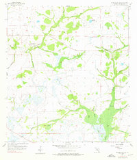
1956 Map of Myakka City NW
USGS Topo · Published 1976About this map
Kibler Ranch and the Kibler Lookout Tower anchor the western portion of this mid-century Florida landscape, illustrating the region's agricultural and forestry management roots. The terrain is defined by an intricate network of waterways and wet prairies, including Johnson Prairie and Coker Prairie. The Myakka River flows through the southeastern quadrant, joined by numerous seasonal drainages such as Ogleby Creek and Sand Slough.
Find a feature on this map
26 named features on this map. Tap any name to fly to it.
Don’t see what you’re looking for? This feature index may not catch every label — zoom into the map to look around manually.
Map Details
Editions of this 1956 Myakka City NW Map
3 editions found
Other maps of this area

1944 · Rye
USGS Topo · 1:31,680

1944 · Verna
USGS Topo · 1:31,680

1944 · Miakka
USGS Topo · 1:31,680

1956 · Myakka City
USGS Topo · 1:24,000

1956 · Edgeville
USGS Topo · 1:24,000

1956 · Myakka City NW
USGS Topo · 1:24,000

1956 · Myakka Head
USGS Topo · 1:24,000

1956 · Duette
USGS Topo · 1:24,000

1956 · Keentown
USGS Topo · 1:24,000

1956 · Tampa
USGS Topo · 1:250,000