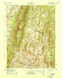
1944 Map of Myersville
USGS Topo · Published 1944About this map
South Mountain and Catoctin Mountain frame this mid-1940s landscape, where small agricultural settlements are connected by a network of creeks and early mountain roads. The town of Myersville sits in the southern valley near Catoctin Creek, while smaller communities like Wolfsville, Smoketown, and Pondsville are scattered throughout the lowlands. A significant detail from the era is the Black Rock Hotel (Ruins) located near Black Rock, hinting at a bygone era of mountain tourism. The map also records early twentieth-century recreation and preservation efforts, including the Washington Monument State Park and a Girl Scout Camp. Notable landmarks for local historians include several named peaks such as Pine Knob, Miller Hill, and Monument Knob, alongside rural institutions like the church at Church Hill and various unnamed cemeteries designated as Cem.
Find a feature on this map
49 named features on this map. Tap any name to fly to it.
Don’t see what you’re looking for? This feature index may not catch every label — zoom into the map to look around manually.
Map Details
Editions of this 1944 Myersville Map
This is the sole edition of this map. No revisions or reprints were ever made.
Other maps of this area

1884 · Harpers Ferry
USGS Topo · 1:125,000

1891 · Harpers Ferry
USGS Topo · 1:125,000

1893 · Frederick
USGS Topo · 1:125,000

1893 · Harpers Ferry
USGS Topo · 1:125,000

1894 · Frederick
USGS Topo · 1:125,000

1908 · Middletown
USGS Topo · 1:48,000

1908 · Ijamsville
USGS Topo · 1:62,500

1909 · Ijamsville
USGS Topo · 1:62,500

1909 · Hagerstown
USGS Topo · 1:48,000

1910 · Antietam
USGS Topo · 1:62,500