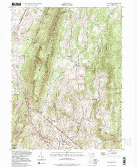
1994 Map of Myersville
USGS Topo · Published 1999About this map
South Mountain forms a dramatic central spine through this portion of the Blue Ridge, separating the Washington and Frederick county line. The landscape is a mix of high-altitude forest and valley floor settlements, with the South Mountain Natural Environmental Area protecting much of the ridge. In the valleys, a dense network of local roads connects historic crossroads like Wolfsville, Jerusalem, and Ellerton. Cultural landmarks such as the St Marks Ch and Mount Aetna Academy are preserved here, alongside numerous small Cem sites that offer valuable data for genealogists. To the south, Washington Monument State Park marks a significant historical waypoint, while the drainage of Catoctin Creek and Middle Creek dictates the placement of early homesteads and agricultural plots throughout the valley floors.
Find a feature on this map
38 named features on this map. Tap any name to fly to it.
Don’t see what you’re looking for? This feature index may not catch every label — zoom into the map to look around manually.
Map Details
Editions of this 1994 Myersville Map
This is the sole edition of this map. No revisions or reprints were ever made.
Other maps of this area

1884 · Harpers Ferry
USGS Topo · 1:125,000

1891 · Harpers Ferry
USGS Topo · 1:125,000

1893 · Frederick
USGS Topo · 1:125,000

1893 · Harpers Ferry
USGS Topo · 1:125,000

1894 · Frederick
USGS Topo · 1:125,000

1908 · Middletown
USGS Topo · 1:48,000

1908 · Ijamsville
USGS Topo · 1:62,500

1909 · Ijamsville
USGS Topo · 1:62,500

1909 · Hagerstown
USGS Topo · 1:48,000

1910 · Antietam
USGS Topo · 1:62,500