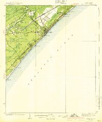
1940 Map of Myrtle Beach
USGS Topo · Published 1940About this map
Myrtle Beach is a developing coastal hub on this pre-war survey, defined by its relationship to the Atlantic and the newly established Intracoastal Waterway. The landscape is a mix of maritime forests and wetlands, where the Atlantic Coast Line Railroad and the historic Kings Highway provide the primary transit corridors. Local life centers on small communities and educational sites like Socastee and the Big Swamp Sch, while the coastline already shows signs of recreational growth at Myrtle Beach State Park and the Ocean Forest Club.
Find a feature on this map
33 named features on this map. Tap any name to fly to it.
Don’t see what you’re looking for? This feature index may not catch every label — zoom into the map to look around manually.
Map Details
Editions of this 1940 Myrtle Beach Map
3 editions found
Other maps of this area

1937 · Myrtle Beach
USGS Topo · 1:48,000

1937 · Nixonville
USGS Topo · 1:48,000

1940 · Myrtle Beach
USGS Topo · 1:62,500

1942 · Nixonville
USGS Topo · 1:62,500

1942 · Magnolia Beach
USGS Topo · 1:24,000

1943 · Wampee
USGS Topo · 1:24,000

1943 · Bucksville
USGS Topo · 1:24,000

1943 · Brookgreen
USGS Topo · 1:24,000

1943 · Conway
USGS Topo · 1:24,000

1949 · Georgetown
USGS Topo · 1:250,000