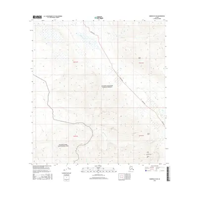
2016 Map of Nabesna B-5 NE
USGS Topo · Published 2016About this map
Nabesna Road cuts a lone path through this wilderness corner of the Alaska Range during the mid-2010s, marking a rare point of human access within the Wrangell-Saint Elias National Preserve. The landscape is defined by the drainage of several waterways, including Jack Creek, Boyden Cr, and Skookum Cr, which carve through the high-elevation terrain. To the south, the boundary shifts into the Wrangell-Saint Elias National Park, where landmarks like White Mtn overlook steep mineral-named features such as Porphyry Gulch, Cliff Gulch, and Garnet Gulch. This survey captures the intersection of federal protected lands and the few corridors used for travel through the Copper River region, illustrating the transition from the preserve to the more strictly managed national park territory.
Find a feature on this map
18 named features on this map. Tap any name to fly to it.
Don’t see what you’re looking for? This feature index may not catch every label — zoom into the map to look around manually.
Map Details
Editions of this 2016 Nabesna B-5 NE Map
This is the sole edition of this map. No revisions or reprints were ever made.
Other maps of this area

1950 · Nabesna
USGS Topo · 1:250,000

1951 · Nabesna
USGS Topo · 1:250,000

1957 · Nabesna C-5
USGS Topo · 1:63,360

1960 · Nabesna B-4
USGS Topo · 1:63,360

1960 · Nabesna B-5
USGS Topo · 1:63,360

1960 · Nabesna
USGS Topo · 1:250,000

1960 · Nabesna C-4
USGS Topo · 1:63,360
1960 · Nabesna C-5
USGS Topo · 1:63,360
2016 · Nabesna B-4 NW
USGS Topo · 1:25,000
2016 · Nabesna B-5 SE
USGS Topo · 1:25,000