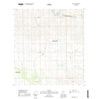
2019 Map of Nabesna C-5 SE
USGS Topo · Published 2019About this map
The Mentasta Mountains dominate this high-altitude landscape within the Wrangell-St. Elias National Preserve, where the drainage patterns of Platinum Creek and Lost Creek define the rugged topography. Access to the interior is limited to a network of historic paths, including the Lost Creek Trail and the Trail Creek To Lost Creek Route, which connect these remote valleys. At lower elevations, Big Grayling Lake sits near the headwaters of Chalk Cr, providing a rare point of standing water amidst the steep terrain.
Find a feature on this map
24 named features on this map. Tap any name to fly to it.
Don’t see what you’re looking for? This feature index may not catch every label — zoom into the map to look around manually.
Map Details
Editions of this 2019 Nabesna C-5 SE Map
This is the sole edition of this map. No revisions or reprints were ever made.
Other maps of this area

1950 · Nabesna
USGS Topo · 1:250,000

1951 · Nabesna
USGS Topo · 1:250,000

1957 · Nabesna C-5
USGS Topo · 1:63,360

1960 · Nabesna B-4
USGS Topo · 1:63,360

1960 · Nabesna B-5
USGS Topo · 1:63,360

1960 · Nabesna
USGS Topo · 1:250,000

1960 · Nabesna C-4
USGS Topo · 1:63,360
1960 · Nabesna C-5
USGS Topo · 1:63,360
2016 · Nabesna C-4 NW
USGS Topo · 1:25,000
2016 · Nabesna B-4 NW
USGS Topo · 1:25,000