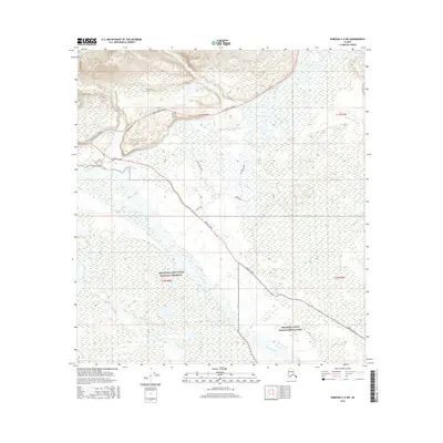
2016 Map of Nabesna C-6 NW
USGS Topo · Published 2016About this map
The confluence of the Slana River and the Copper River anchor this Alaskan landscape where several key transit corridors meet. Centered on the Tok Cutoff Highway and the beginning of Nabesna Road, the map documents a transition from the Wrangell-Saint Elias National Preserve into the Wrangell-Saint Elias National Park. Aviation history and local access are represented by Duffys Tavern Airport, situated near the intersection of these primary routes.
Find a feature on this map
21 named features on this map. Tap any name to fly to it.
Don’t see what you’re looking for? This feature index may not catch every label — zoom into the map to look around manually.
Map Details
Editions of this 2016 Nabesna C-6 NW Map
This is the sole edition of this map. No revisions or reprints were ever made.
Other maps of this area

1948 · Nabesna C-6
USGS Topo · 1:63,360

1949 · Nabesna D-6
USGS Topo · 1:63,360

1949 · Gulkana C-1
USGS Topo · 1:63,360

1950 · Nabesna
USGS Topo · 1:250,000

1951 · Gulkana
USGS Topo · 1:250,000

1951 · Nabesna
USGS Topo · 1:250,000

1952 · Nabesna C-6
USGS Topo · 1:63,360

1952 · Nabesna D-6
USGS Topo · 1:63,360

1952 · Gulkana C-1
USGS Topo · 1:63,360
1954 · Gulkana D-1
USGS Topo · 1:63,360