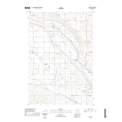
2020 Map of Naches
USGS Topo · Published 2020About this map
The Upper Naches Valley and Lower Naches Valley dominate this landscape, where the Naches River carves a fertile corridor between high ridges. The area's agricultural identity is clearly defined by an intricate network of irrigation systems, including the Wapatox Canal, Selah Valley Canal, and several major ditches like the Lowry Ditch. These waterways support a string of established settlements and shipping points, from the town of Naches in the north to Cowiche and the fruit-growing hub of Holtzinger further south.
Find a feature on this map
83 named features on this map. Tap any name to fly to it.
Don’t see what you’re looking for? This feature index may not catch every label — zoom into the map to look around manually.
Map Details
Editions of this 2020 Naches Map
This is the sole edition of this map. No revisions or reprints were ever made.
Other maps of this area

1899 · Ellensburg
USGS Topo · 1:125,000

1901 · Ellensburg
USGS Topo · 1:125,000

1950 · Yakima
USGS Topo · 1:250,000

1958 · Ellensburg
USGS Topo · 1:62,500
1958 · Yakima West
USGS Topo · 1:24,000
1958 · Selah
USGS Topo · 1:24,000

1958 · Wiley City
USGS Topo · 1:24,000

1958 · Naches
USGS Topo · 1:24,000

1958 · Yakima
USGS Topo · 1:250,000

1961 · Yakima
USGS Topo · 1:250,000