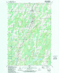
1989 Map of Nadeau
USGS Topo · Published 1989About this map
Nadeau and Carney serve as central nodes in this Upper Peninsula landscape, where a transition from agricultural clearings to dense woodland is evident. Small settlements like Bagley and Talbot are documented alongside the Little Cedar River, reflecting the region's historic reliance on water and rail corridors. The presence of the Swedish Cem and Maple Grove Cem provides specific points of interest for genealogists tracing local families in Menominee County. Much of the southern and eastern portions of the map are defined by the Escanaba River State Forest, while local infrastructure is marked by a Landing Strip and an Industrial Waste Pond. This 1980s revision illustrates the persistent rural character of the area, featuring a network of creeks including Potterfield Creek and Holmes Creek that feed into the larger river systems.
Find a feature on this map
27 named features on this map. Tap any name to fly to it.
Don’t see what you’re looking for? This feature index may not catch every label — zoom into the map to look around manually.
Map Details
Editions of this 1989 Nadeau Map
This is the sole edition of this map. No revisions or reprints were ever made.
Other maps of this area

1949 · Stephenson
USGS Topo · 1:48,000

1954 · Escanaba
USGS Topo · 1:250,000

1957 · Escanaba
USGS Topo · 1:250,000

1958 · Escanaba
USGS Topo · 1:250,000

1963 · Bark River
USGS Topo · 1:62,500

1963 · Powers
USGS Topo · 1:62,500

1963 · Cedar River
USGS Topo · 1:62,500

1963 · Stephenson
USGS Topo · 1:62,500

1981 · Marinette
USGS Topo · 1:100,000

1982 · Escanaba
USGS Topo · 1:100,000