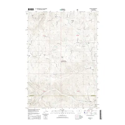
2015 Map of Nahant
USGS Topo · Published 2015About this map
Dumont and Nahant sit within the high-elevation terrain of the Black Hills National Forest, where the landscape is defined by a dense network of gulches and draws. This 2015 survey reveals a wilderness marked by historical land use, particularly around Ward Cem and the nearby Graveyard Spring. The area serves as a significant drainage basin, with the N Fork Rapid Cr and S Fork Rapid Cr cutting through the mountainous topography. The map illustrates how modern access via Rochford Road and Nahant Rd follows the natural contours established by earlier settlers and foresters. Local history is preserved in family-named landmarks such as Gudat Gulch, Billings Draw, and Harvey Spring, suggesting a legacy of early homesteading or ranching in these isolated South Dakota valleys.
Find a feature on this map
56 named features on this map. Tap any name to fly to it.
Don’t see what you’re looking for? This feature index may not catch every label — zoom into the map to look around manually.
Map Details
Editions of this 2015 Nahant Map
This is the sole edition of this map. No revisions or reprints were ever made.
Other maps of this area

1894 · Deadwood
USGS Topo · 1:125,000

1899 · Sturgis
USGS Topo · 1:62,500

1900 · Spearfish
USGS Topo · 1:62,500

1901 · Deadwood
USGS Topo · 1:125,000

1915 · Spearfish
USGS Topo · 1:62,500

1915 · Sturgis
USGS Topo · 1:62,500

1916 · Deadwood
USGS Topo · 1:125,000

1953 · Rapid City
USGS Topo · 1:250,000
1956 · Crooks Tower
USGS Topo · 1:24,000
1956 · Crows Nest Peak
USGS Topo · 1:24,000