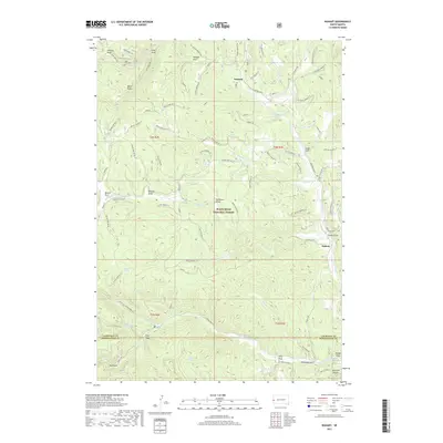
2017 Map of Nahant
USGS Topo · Published 2017About this map
Dumont and Nahant sit within the heavily wooded interior of the Black Hills National Forest, where high-altitude drainages define the landscape. This 2017 survey shows a complex network of forest service roads and timber access routes, such as the Rochford Road and Stageyard 155, which crisscross the high ridges between deep-cut gulches. Water sources are vital markers in this terrain, with named springs like Black Fox Spring and Rickgauer Spring feeding into the N Fork Rapid Cr and S Fork Rapid Cr. Genealogists and local historians can locate the Ward Cem near Hollens Draw in the northwest corner, a quiet landmark amidst the vast timber stands. The map also captures numerous family-named gulches and draws, including Solomon Gulch, Swede Gulch, and Gudat Gulch, reflecting the region's long history of ranching and resource extraction.
Find a feature on this map
82 named features on this map. Tap any name to fly to it.
Don’t see what you’re looking for? This feature index may not catch every label — zoom into the map to look around manually.
Map Details
Editions of this 2017 Nahant Map
This is the sole edition of this map. No revisions or reprints were ever made.
Other maps of this area

1894 · Deadwood
USGS Topo · 1:125,000

1899 · Sturgis
USGS Topo · 1:62,500

1900 · Spearfish
USGS Topo · 1:62,500

1901 · Deadwood
USGS Topo · 1:125,000

1915 · Spearfish
USGS Topo · 1:62,500

1915 · Sturgis
USGS Topo · 1:62,500

1916 · Deadwood
USGS Topo · 1:125,000

1953 · Rapid City
USGS Topo · 1:250,000
1956 · Crooks Tower
USGS Topo · 1:24,000
1956 · Crows Nest Peak
USGS Topo · 1:24,000