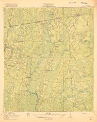
1918 Map of Nahunta
USGS Topo · Published 1918About this map
The Satilla River meanders through this southeast Georgia landscape, its corridor defined by a complex network of wetlands and named oxbows like Buck Lake and Long Lake. This 1917 survey reveals a rural society structured around local community hubs, evidenced by a high density of neighborhood schools such as Pine Bloom School, Oak Grove School, and Clarke School. The Atlantic Coast Line railroad provides the primary east-west axis, connecting settlements like Nahunta, Lulaton, and Waynesville.
Find a feature on this map
49 named features on this map. Tap any name to fly to it.
Don’t see what you’re looking for? This feature index may not catch every label — zoom into the map to look around manually.
Map Details
Editions of this 1918 Nahunta Map
2 editions found
Other maps of this area

1917 · Nahunta
USGS Topo · 1:62,500

1917 · Boulogne
USGS Topo · 1:62,500

1918 · Folkston
USGS Topo · 1:62,500

1918 · Hortense
USGS Topo · 1:62,500

1918 · Everett City
USGS Topo · 1:62,500

1918 · Nahunta
USGS Topo · 1:62,500

1918 · Bladen
USGS Topo · 1:62,500

1918 · Kingsland
USGS Topo · 1:62,500

1919 · Boulogne
USGS Topo · 1:62,500

1920 · Everett City
USGS Topo · 1:62,500