
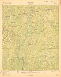
1918 Map of Nahunta
USGS Topo · Published 1918About this map
The Satilla River meanders through the heart of this coastal plain landscape, defining the boundaries of Wayne, Camden, and Charlton counties during the early twentieth century. This 1917 survey reveals a rural society structured around the Atlantic Coast Line railroad and a network of named country schools like Pine Bloom School and Little Satilla School. The presence of Ammons Ferry Bridge and the Jacksonville Post Road underscores the importance of the river crossings and overland trails in an era before modern highway expansion. Low-lying wetlands, including Waverly Swamp and Whiteoak Swamp, dominate the eastern portion of the sheet, while small settlements such as Waynesville and Atkinson serve as rail-side anchors for the surrounding timber and agricultural interests. For genealogists, the map preserves the locations of early congregational centers like Bixley Chapel and Providence Church.
Find a feature on this map
47 named features on this map. Tap any name to fly to it.
Don’t see what you’re looking for? This feature index may not catch every label — zoom into the map to look around manually.
Map Details
Editions of this 1918 Nahunta Map
2 editions found
Other maps of this area

1917 · Nahunta
USGS Topo · 1:62,500

1917 · Boulogne
USGS Topo · 1:62,500

1918 · Folkston
USGS Topo · 1:62,500

1918 · Hortense
USGS Topo · 1:62,500

1918 · Everett City
USGS Topo · 1:62,500

1918 · Bladen
USGS Topo · 1:62,500

1918 · Kingsland
USGS Topo · 1:62,500

1919 · Boulogne
USGS Topo · 1:62,500

1920 · Everett City
USGS Topo · 1:62,500

1939 · Bladen
USGS Topo · 1:62,500