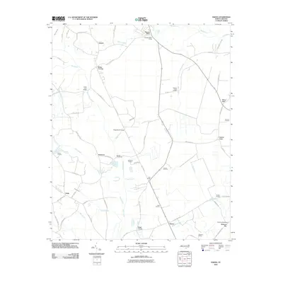
2010 Map of Nakina
USGS Topo · Published 2010About this map
Nakina and the surrounding coastal plain of Columbus County are defined by a network of swamps and slow-moving branches. Small settlements such as Antioch, Mollie, and Whites Crossing dot the landscape, connected by a grid of rural roads and bridges over water bodies like Mollie Swamp and Gum Swamp. The presence of numerous family-named landmarks, such as Ward Corner and the McKeithan Cemetery, reflects the long-standing community ties in this agricultural region. The landscape is heavily influenced by the drainage patterns of the Big Branch and Cypress Creek, which dictate the placement of local infrastructure. Evidence of former industry remains in the presence of Old Tram Rd, indicating the area's history with timber or rail transport. This survey provides a clear view of the rural habitation and hydrography south of Whiteville in the early twenty-first century.
Find a feature on this map
72 named features on this map. Tap any name to fly to it.
Don’t see what you’re looking for? This feature index may not catch every label — zoom into the map to look around manually.
Map Details
Editions of this 2010 Nakina Map
This is the sole edition of this map. No revisions or reprints were ever made.
Other maps of this area

1943 · Pireway
USGS Topo · 1:31,680

1943 · Nakina
USGS Topo · 1:24,000

1943 · Freeland
USGS Topo · 1:24,000
1953 · Pireway
USGS Topo · 1:24,000

1953 · Chadbourn
USGS Topo · 1:62,500

1953 · Florence
USGS Topo · 1:250,000

1954 · Florence
USGS Topo · 1:250,000

1955 · Whiteville
USGS Topo · 1:62,500
1962 · Goretown
USGS Topo · 1:24,000
1962 · Tabor City East
USGS Topo · 1:24,000