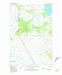
1951 Map of Naknek B-1
USGS Topo · Published 1981About this map
Katmai National Monument dominates the topography of this 1951 aerial survey, representing a remote stretch of the Alaska Peninsula during the early decades of the monument's establishment. The landscape is defined by the transition from the high waters of Lake Brooks in the northeast to the sprawling wetland and tundra systems of Becharof in the southwest. A lone landmark, Granite, stands along the central-western border, providing a rare named point of reference in an otherwise undeveloped wilderness. The map reveals the intricate drainage patterns and small glacial lakes that characterize this subarctic environment before modern infrastructure or expanded park boundaries altered the region's footprint. The absence of roads or trails across the entire quadrangle emphasizes the isolation and untouched state of this territory in the mid-twentieth century.
Find a feature on this map
5 named features on this map. Tap any name to fly to it.
Don’t see what you’re looking for? This feature index may not catch every label — zoom into the map to look around manually.
Map Details
Editions of this 1951 Naknek B-1 Map
2 editions found
Other maps of this area

1948 · Mt Katmai
USGS Topo · 1:250,000

1951 · Mt Katmai
USGS Topo · 1:250,000

1951 · Mount Katmai A-6
USGS Topo · 1:63,360

1951 · Mount Katmai C-6
USGS Topo · 1:63,360

1951 · Mount Katmai B-6
USGS Topo · 1:63,360

1951 · Naknek B-1
USGS Topo · 1:63,360

1951 · Naknek C-1
USGS Topo · 1:63,360

1951 · Naknek A-2
USGS Topo · 1:63,360

1951 · Naknek A-1
USGS Topo · 1:63,360

1952 · Naknek
USGS Topo · 1:250,000