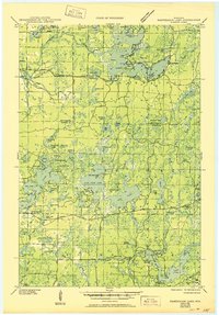
1945 Map of Namekagon Lake
USGS Topo · Published 1950About this map
The Namekagon River winds through this heavily glaciated landscape of northern Wisconsin, which was surveyed during the mid-1940s when much of the area was already protected as National Forest. This map reveals a transition from a logging-centered economy to one of seasonal recreation and conservation, evidenced by the presence of the Lost Land Lake Club and the Sawyer CCC Camp in the southeast. Water is the defining characteristic of the terrain, with dozens of named kettle lakes such as Eagle Nest Lake, Lost Land Lake, and Hidden Lake scattered across the boundary of Bayfield Co and Sawyer Co. Human infrastructure remains sparse but vital, featuring the West Fork Fire Tower for forest management and localized water controls like Tiger Cat Dam and West Fork Dam. For genealogists and local historians, the placement of the Spider Lake Sch and the small settlement of Currier offers a window into the isolated community life of the era.
Find a feature on this map
89 named features on this map. Tap any name to fly to it.
Don’t see what you’re looking for? This feature index may not catch every label — zoom into the map to look around manually.
Map Details
Editions of this 1945 Namekagon Lake Map
2 editions found
Other maps of this area

1942 · Clam Lake
USGS Topo · 1:48,000

1942 · Marengo
USGS Topo · 1:48,000

1943 · Namekagon Lake
USGS Topo · 1:48,000

1944 · Draper
USGS Topo · 1:48,000

1944 · Couderay
USGS Topo · 1:48,000

1944 · Radisson
USGS Topo · 1:48,000

1944 · Drummond
USGS Topo · 1:48,000

1944 · Grandview
USGS Topo · 1:48,000

1944 · Hayward
USGS Topo · 1:48,000

1945 · Namekagon Lake
USGS Topo · 1:48,000