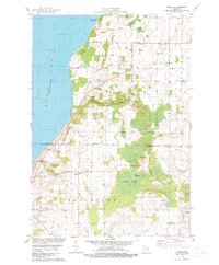
1978 Map of Namur
USGS Topo · Published 1979About this map
The Belgian heritage of the Door Peninsula is evident across this landscape in the late 1970s, where rural routes like Belgian Drive connect scattered farming communities. The settlement of Namur serves as a local focal point near the northern edge, while the interior is characterized by a network of family-named landmarks and religious sites including St Francis Ch and multiple locations for St Marys Cem.
Find a feature on this map
36 named features on this map. Tap any name to fly to it.
Don’t see what you’re looking for? This feature index may not catch every label — zoom into the map to look around manually.
Map Details
Editions of this 1978 Namur Map
2 editions found
Other maps of this area

1952 · Casco
USGS Topo · 1:62,500

1954 · New Franken
USGS Topo · 1:62,500

1954 · Manitowoc
USGS Topo · 1:250,000

1956 · Oconto
USGS Topo · 1:62,500

1958 · Manitowoc
USGS Topo · 1:250,000

1961 · Little Sturgeon
USGS Topo · 1:62,500
1974 · Oconto SE
USGS Topo · 1:24,000

1978 · Casco
USGS Topo · 1:24,000

1978 · Namur
USGS Topo · 1:24,000
1978 · Luxemburg
USGS Topo · 1:24,000