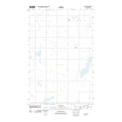
2011 Map of Nanson
USGS Topo · Published 2011About this map
Nanson sits at the heart of this North Dakota prairie landscape, situated near the intersection of 80th St NE and 41st Ave NE. The geography is defined by the subtle drainages of Ox Creek and the expansive waters of Twin Lakes to the east. A grid of section-line roads, including Rolette Rd and 39th Ave NE, organizes the agricultural terrain, reflecting the enduring legacy of the Public Land Survey System in Rolette County. To the north, the North Ox Creek Cemetery serves as a quiet landmark of local genealogy and settlement history. The map illustrates a rural environment where water bodies and isolated structures dictate the flow of travel through the northern plains.
Find a feature on this map
19 named features on this map. Tap any name to fly to it.
Don’t see what you’re looking for? This feature index may not catch every label — zoom into the map to look around manually.
Map Details
Editions of this 2011 Nanson Map
This is the sole edition of this map. No revisions or reprints were ever made.
Other maps of this area

1953 · Devils Lake
USGS Topo · 1:250,000

1954 · Rugby NW
USGS Topo · 1:24,000

1955 · Thorne
USGS Topo · 1:24,000

1955 · Rolette SW
USGS Topo · 1:24,000

1956 · Devils Lake
USGS Topo · 1:250,000

1971 · Wolford
USGS Topo · 1:24,000

1971 · Island Lake
USGS Topo · 1:24,000

1971 · Rugby NE
USGS Topo · 1:24,000

1971 · Mylo NW
USGS Topo · 1:24,000
1971 · Rolette
USGS Topo · 1:24,000