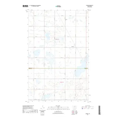
2017 Map of Nanson
USGS Topo · Published 2017About this map
Nanson and the prairie landscape of north-central North Dakota are defined here by a rhythmic grid of county roads and a sprawling network of wetlands. Located near the border of Rolette Co and Pierce Co, the terrain is marked by numerous glacial potholes and depressions, including the prominent Twin Lakes to the southeast. The rural character of the region is evident in the presence of the North Ox Creek Cem along 40th Ave NE, serving as a vital landmark for genealogists tracing local families. Seasonal drainage via Ox Cr weaves through the northwestern sections, crossing Willow City Rd. This survey documents the persistent agricultural footprint of the plains, where designated township boundaries like t159n r71w and t158n r71w dictate the movement of travelers along routes such as Rolette Rd.
Find a feature on this map
25 named features on this map. Tap any name to fly to it.
Don’t see what you’re looking for? This feature index may not catch every label — zoom into the map to look around manually.
Map Details
Editions of this 2017 Nanson Map
This is the sole edition of this map. No revisions or reprints were ever made.
Other maps of this area

1953 · Devils Lake
USGS Topo · 1:250,000

1954 · Rugby NW
USGS Topo · 1:24,000

1955 · Thorne
USGS Topo · 1:24,000

1955 · Rolette SW
USGS Topo · 1:24,000

1956 · Devils Lake
USGS Topo · 1:250,000

1971 · Wolford
USGS Topo · 1:24,000

1971 · Island Lake
USGS Topo · 1:24,000

1971 · Rugby NE
USGS Topo · 1:24,000

1971 · Mylo NW
USGS Topo · 1:24,000
1971 · Rolette
USGS Topo · 1:24,000