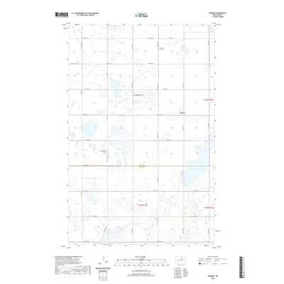
2020 Map of Nanson
USGS Topo · Published 2020About this map
Nanson sits at the heart of this prairie landscape, where the boundary between Rolette Co and Pierce Co divides a region defined by glacial wetlands and agriculture. The settlement pattern is anchored by local heritage sites, specifically the North Ox Creek Cem and the South Ox Creek Lutheran Cem, which serve as vital landmarks for genealogists tracing family roots in this part of North Dakota. A network of section-line roads like Willow City Rd and 80th St NE creates a rigid grid across the terrain, navigating around natural features such as Twin Lakes and the winding course of Ox Cr. This survey illustrates the enduring rural structure of the Great Plains, where small communities and quiet churchyards remain the primary focal points of the township.
Find a feature on this map
21 named features on this map. Tap any name to fly to it.
Don’t see what you’re looking for? This feature index may not catch every label — zoom into the map to look around manually.
Map Details
Editions of this 2020 Nanson Map
This is the sole edition of this map. No revisions or reprints were ever made.
Other maps of this area

1953 · Devils Lake
USGS Topo · 1:250,000

1954 · Rugby NW
USGS Topo · 1:24,000

1955 · Thorne
USGS Topo · 1:24,000

1955 · Rolette SW
USGS Topo · 1:24,000

1956 · Devils Lake
USGS Topo · 1:250,000

1971 · Wolford
USGS Topo · 1:24,000

1971 · Island Lake
USGS Topo · 1:24,000

1971 · Rugby NE
USGS Topo · 1:24,000

1971 · Mylo NW
USGS Topo · 1:24,000
1971 · Rolette
USGS Topo · 1:24,000