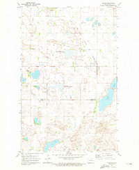
1971 Map of Nanson
USGS Topo · Published 1973About this map
Nanson sits as a central settlement amidst a prairie landscape dominated by wetlands and conservation areas during the early 1970s. The geography is defined by the Rice Township National Wildlife Refuge and the Elbow Lake National Wildlife Refuge, indicating a region heavily managed for migratory waterfowl and native habitats. Local life and history are anchored by landmarks like the Ox Creek Ch and North Ox Creek Cem, while the Burlington Northern railroad provides the primary industrial artery through the terrain. The presence of numerous bodies of water, including Twin Lakes, Elbow Lake, and the winding Ox Creek, reflects the glaciated pothole character of this part of the North Dakota plains, where small-scale extraction is evidenced by a Gravel Pit near the northern boundary.
Find a feature on this map
15 named features on this map. Tap any name to fly to it.
Don’t see what you’re looking for? This feature index may not catch every label — zoom into the map to look around manually.
Map Details
Editions of this 1971 Nanson Map
This is the sole edition of this map. No revisions or reprints were ever made.
Other maps of this area

1953 · Devils Lake
USGS Topo · 1:250,000

1954 · Rugby NW
USGS Topo · 1:24,000

1955 · Thorne
USGS Topo · 1:24,000

1955 · Rolette SW
USGS Topo · 1:24,000

1956 · Devils Lake
USGS Topo · 1:250,000

1971 · Wolford
USGS Topo · 1:24,000

1971 · Island Lake
USGS Topo · 1:24,000

1971 · Rugby NE
USGS Topo · 1:24,000

1971 · Mylo NW
USGS Topo · 1:24,000
1971 · Rolette
USGS Topo · 1:24,000