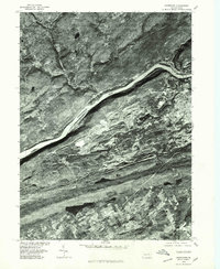
1976 Map of Nanticoke
USGS Topo · Published 1979About this map
The Susquehanna River cuts a prominent diagonal across this mid-1970s orthophotoquad, defining the industrial and geographic character of Luzerne County. This aerial perspective, prepared by the Geological Survey in cooperation with the Soil Conservation Service, reveals the intensive land use surrounding Nanticoke and Glen Lyon. The imagery captures the heavy scarring and terracing of anthracite coal mining operations that dominate the landscape between the river and the ridgeline of Penobscot Mountain. Smaller rural clusters like Hunlock and Slocum Corners provide a sharp contrast to the dense urban grids and industrial disturbances. The photograph, taken in October 1976, provides a stark record of the region's topography before modern reclamation efforts altered the visible footprints of the valley's mining legacy.
Find a feature on this map
6 named features on this map. Tap any name to fly to it.
Don’t see what you’re looking for? This feature index may not catch every label — zoom into the map to look around manually.
Map Details
Editions of this 1976 Nanticoke Map
This is the sole edition of this map. No revisions or reprints were ever made.
Other maps of this area

1891 · Wilkesbarre
USGS Topo · 1:62,500

1891 · Harveys Lake
USGS Topo · 1:62,500

1893 · Harvey Lake
USGS Topo · 1:62,500

1893 · Pittston
USGS Topo · 1:62,500

1894 · Shickshinny
USGS Topo · 1:62,500

1894 · Wilkesbarre
USGS Topo · 1:62,500

1943 · Scranton
USGS Topo · 1:125,000

1946 · Sybertsville
USGS Topo · 1:31,680

1946 · Nanticoke
USGS Topo · 1:31,680

1946 · Shickshinny
USGS Topo · 1:31,680