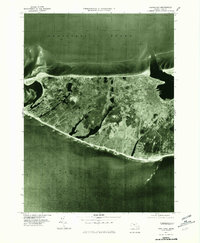
1977 Map of Nantucket
USGS Topo · Published 1981About this map
Nantucket Island is captured here in a 1977 orthophotoquad, which uses aerial photography to provide a clear, literal view of the landscape rather than traditional topographic symbols. This perspective reveals the dense cluster of the main Nantucket settlement on the eastern harbor, contrasted with the sparse development at Madaket to the west. The photographic detail makes visible the distinct inland ponds, scrub vegetation, and coastal erosion patterns along the south shore near Cisco and Surfside. Produced by the Geological Survey in cooperation with the Commonwealth of Massachusetts Department of Public Works, this map serves as a precise record of the island's coastal morphology and land use during the late 1970s. The transition between the calm waters of Nantucket Sound to the north and the open Atlantic Ocean to the south highlights the island's vulnerability to the sea.
Find a feature on this map
7 named features on this map. Tap any name to fly to it.
Don’t see what you’re looking for? This feature index may not catch every label — zoom into the map to look around manually.
Map Details
Editions of this 1977 Nantucket Map
This is the sole edition of this map. No revisions or reprints were ever made.
Other maps of this area

1887 · Muskeget
USGS Topo · 1:62,500

1889 · Muskeget
USGS Topo · 1:62,500

1889 · Nantucket
USGS Topo · 1:62,500

1893 · Nantucket
USGS Topo · 1:62,500

1893 · Muskeget
USGS Topo · 1:62,500

1899 · Muskeget
USGS Topo · 1:62,500

1901 · Nantucket
USGS Topo · 1:62,500

1942 · Nantucket
USGS Topo · 1:125,000

1944 · Tuckernuck Island
USGS Topo · 1:31,680

1945 · Nantucket
USGS Topo · 1:31,680