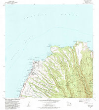
1983 Map of Napili
USGS Topo · Published 1984About this map
Napili and the northwestern coast of Maui appear in this early 1980s record of development and geography. The coastline is defined by a succession of points and bays, from Nakalele Pt in the north down to Mahinahina Pt. Inland, the terrain rises sharply into the West Maui Forest Reserve, carved by numerous deep gulches such as Honolua Stream and Honokohau Stream. This era shows the established community at Napili alongside legacy agricultural infrastructure like the Honokowai Ditch. The presence of a Heiau near Honokohau and a Cem near Honokahua Bay provides important touchpoints for cultural and genealogical research. The map captures a moment of transition where coastal recreation at places like Fleming Beach exists alongside traditional water management systems and the forested interior heights of Puu Kaeo.
Find a feature on this map
80 named features on this map. Tap any name to fly to it.
Don’t see what you’re looking for? This feature index may not catch every label — zoom into the map to look around manually.
Map Details
Editions of this 1983 Napili Map
2 editions found
Other maps of this area

1952 · Halawa
USGS Topo · 1:24,000

1954 · Maui
USGS Topo · 1:250,000

1955 · Wailuku
USGS Topo · 1:24,000

1955 · Kahakuloa
USGS Topo · 1:24,000

1956 · Lahaina
USGS Topo · 1:24,000

1956 · Honolua
USGS Topo · 1:24,000

1966 · Maui
USGS Topo · 1:250,000

1968 · Halawa
USGS Topo · 1:24,000

1974 · Maui
USGS Topo · 1:250,000

1977 · Wailuku
USGS Topo · 1:24,000