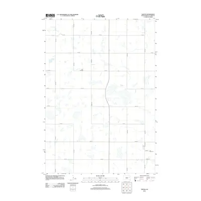
2012 Map of Naples
USGS Topo · Published 2012About this map
Naples Cem and Saint Patricks Cem serve as focal points for this section of Clark County, South Dakota, reflecting the rural township's burial grounds and community legacy. The landscape is defined by a rigid section-line grid of local roads, such as 430th Ave and 176th St, which organize the agricultural terrain. Water features are interspersed throughout the grid, with several lakes and wetlands punctuating the prairie. In the eastern portion of the quadrangle, the small settlement structure is visible along Hollister St and 1st St, near where Co Hwy-10 provides a primary transit link. To the northwest, the South Elrod Cem marks another historical site within the open plains, illustrating the scattered nature of early development in this region of the Dakotas.
Find a feature on this map
19 named features on this map. Tap any name to fly to it.
Don’t see what you’re looking for? This feature index may not catch every label — zoom into the map to look around manually.
Map Details
Editions of this 2012 Naples Map
This is the sole edition of this map. No revisions or reprints were ever made.
Other maps of this area

1953 · Watertown
USGS Topo · 1:250,000

1958 · Watertown
USGS Topo · 1:250,000

1973 · Garden City
USGS Topo · 1:24,000
1973 · Henry
USGS Topo · 1:24,000

1973 · Willow Lake
USGS Topo · 1:24,000

1973 · Clark South
USGS Topo · 1:24,000
1973 · Clark North
USGS Topo · 1:24,000

1973 · Vienna West
USGS Topo · 1:24,000

1973 · Naples
USGS Topo · 1:24,000

1973 · Vienna East
USGS Topo · 1:24,000