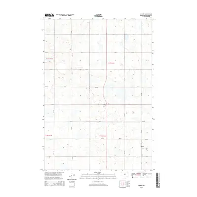
2015 Map of Naples
USGS Topo · Published 2015About this map
Coteau des Prairies, a vast glacial upland, defines the rolling topography of this Clark County landscape. The small settlement of Naples sits in the southeastern corner, serving as a focal point for the surrounding agricultural sections. The map reveals a highly structured grid of section roads, including 174th St and 430th Ave, which partition the prairie into a network of farmsteads and fields. For those researching local family history, several burial sites are clearly marked, including Saint Patricks Cem and Naples Cem near the townsite, along with the more isolated South Elrod Cem to the northwest. Numerous small potholes and wetlands are scattered throughout the terrain, illustrating the distinct drainage patterns of this high prairie region before it descends toward the surrounding lowlands.
Find a feature on this map
24 named features on this map. Tap any name to fly to it.
Don’t see what you’re looking for? This feature index may not catch every label — zoom into the map to look around manually.
Map Details
Editions of this 2015 Naples Map
This is the sole edition of this map. No revisions or reprints were ever made.
Other maps of this area

1953 · Watertown
USGS Topo · 1:250,000

1958 · Watertown
USGS Topo · 1:250,000

1973 · Garden City
USGS Topo · 1:24,000
1973 · Henry
USGS Topo · 1:24,000

1973 · Willow Lake
USGS Topo · 1:24,000

1973 · Clark South
USGS Topo · 1:24,000
1973 · Clark North
USGS Topo · 1:24,000

1973 · Vienna West
USGS Topo · 1:24,000

1973 · Naples
USGS Topo · 1:24,000

1973 · Vienna East
USGS Topo · 1:24,000