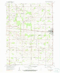
1958 Map of Nappanee West
USGS Topo · Published 1984About this map
Nappanee anchors this survey of North Central Indiana, showing the city's western outskirts as they appeared in the late 1950s. The landscape is defined by an intricate network of drainage systems, including the Newcomer Ditch and Shively Ditch, which supported the region's intensive agricultural development across county lines. The Baltimore and Ohio Railroad and the Army Of The Republic Highway form the primary east-west corridors, linking the established town center to outlying settlements like Locke and Bixler. Community life of the era is evidenced by numerous rural institutions, from the Borkholder Sch and Weldy Sch to several country churches such as Oak Grove Ch and South Union Chapel. The grid of named section roads and family-named ditches reveals a highly managed landscape, where local infrastructure was deeply tied to individual farmsteads and small crossroads communities.
Find a feature on this map
82 named features on this map. Tap any name to fly to it.
Don’t see what you’re looking for? This feature index may not catch every label — zoom into the map to look around manually.
Map Details
Editions of this 1958 Nappanee West Map
3 editions found
Other maps of this area

1953 · Fort Wayne
USGS Topo · 1:250,000

1953 · Chicago
USGS Topo · 1:250,000

1956 · Fort Wayne
USGS Topo · 1:250,000

1957 · Chicago
USGS Topo · 1:250,000

1957 · Inwood
USGS Topo · 1:24,000

1958 · Bremen
USGS Topo · 1:24,000

1958 · Nappanee West
USGS Topo · 1:24,000

1958 · Nappanee East
USGS Topo · 1:24,000

1958 · Bourbon
USGS Topo · 1:24,000

1959 · Atwood
USGS Topo · 1:24,000