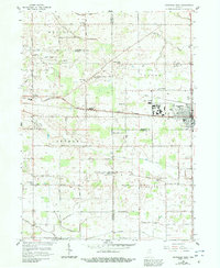
1958 Map of Nappanee West
USGS Topo · Published 1991About this map
Nappanee and the village of Locke anchor this landscape along the border of Elkhart and Marshall counties during the late 1950s. The region is defined by a dense network of country schools and churches that served the agricultural community, including the Borkholder Sch, Weldy Sch, and the South Union Chapel. The Army of the Republic Highway cuts an east-west path across the center, passing the outskirts of town and several family-named landmarks.
Find a feature on this map
55 named features on this map. Tap any name to fly to it.
Don’t see what you’re looking for? This feature index may not catch every label — zoom into the map to look around manually.
Map Details
Editions of this 1958 Nappanee West Map
3 editions found
Other maps of this area

1953 · Fort Wayne
USGS Topo · 1:250,000

1953 · Chicago
USGS Topo · 1:250,000

1956 · Fort Wayne
USGS Topo · 1:250,000

1957 · Chicago
USGS Topo · 1:250,000

1957 · Inwood
USGS Topo · 1:24,000

1958 · Bremen
USGS Topo · 1:24,000

1958 · Nappanee West
USGS Topo · 1:24,000

1958 · Nappanee East
USGS Topo · 1:24,000

1958 · Bourbon
USGS Topo · 1:24,000

1959 · Atwood
USGS Topo · 1:24,000