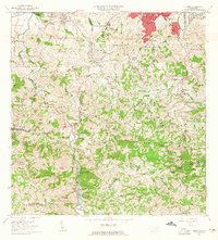
1963 Map of Naranjito
USGS Topo · Published 1965About this map
Naranjito and the surrounding central highlands are captured in this mid-century survey, revealing a landscape defined by sharp elevation changes and early industrial infrastructure. The presence of the Planta Hidroeléctrica Comerío No 1 and Planta Hidroeléctrica Comerío No 2 on the interior river system highlights the region's importance for power generation during Puerto Rico's era of modernization.
Find a feature on this map
108 named features on this map. Tap any name to fly to it.
Don’t see what you’re looking for? This feature index may not catch every label — zoom into the map to look around manually.
Map Details
Editions of this 1963 Naranjito Map
This is the sole edition of this map. No revisions or reprints were ever made.
Other maps of this area

1940 · Vega Alta
USGS Topo · 1:30,000

1941 · Bayamon
USGS Topo · 1:30,000

1941 · San Juan
USGS Topo · 1:30,000

1946 · Aguas Buenas
USGS Topo · 1:30,000

1946 · Corozal
USGS Topo · 1:30,000

1946 · Barranquitas
USGS Topo · 1:30,000

1946 · Vega Alta
USGS Topo · 1:30,000

1946 · Comerio
USGS Topo · 1:30,000

1946 · Naranjito
USGS Topo · 1:30,000

1946 · Caguas
USGS Topo · 1:30,000
Featured Places
- Naranjito, Naranjito
- Sector Correa, Naranjito
- Villas del Olimpo, Bayamón
- Sector La Capilla, Bayamón
- Sector González, Bayamón