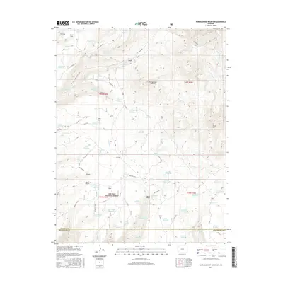
2016 Map of Narraguinnep Mountain
USGS Topo · Published 2016About this map
Narraguinnep Mountain serves as a prominent landmark within the San Juan National Forest, overlooking a landscape defined by an extensive system of water management. The terrain is marked by numerous small-scale reservoirs such as Barney Reservoir, Hosea Reservoir, and Rock Bottom Reservoir, which suggest a history of seasonal water storage and cattle ranching across the high country. The map captures the complex topography of the Narraguinnep Ridge and the Flat Iron benches, where drainages like Canyon Cr and Ferris Canyon have carved deep into the southwestern Colorado landscape. Significant local landmarks, including Ormiston Point and the Dry Lake Cutoff, provide points of orientation for those tracing historic movement through this part of the forest. The concentration of reservoirs and springs indicates a landscape heavily modified to support rural activities in an otherwise arid region.
Find a feature on this map
90 named features on this map. Tap any name to fly to it.
Don’t see what you’re looking for? This feature index may not catch every label — zoom into the map to look around manually.
Map Details
Editions of this 2016 Narraguinnep Mountain Map
This is the sole edition of this map. No revisions or reprints were ever made.
Other maps of this area

1956 · Cortez
USGS Topo · 1:250,000

1958 · Cortez
USGS Topo · 1:250,000

1959 · Cortez
USGS Topo · 1:250,000

1962 · Cortez
USGS Topo · 1:250,000

1964 · Glade Mountain
USGS Topo · 1:24,000

1964 · The Glade
USGS Topo · 1:24,000
1964 · South Mountain
USGS Topo · 1:24,000

1965 · Willow Spring
USGS Topo · 1:24,000

1965 · Yellow Jacket
USGS Topo · 1:24,000
1965 · Boggy Draw
USGS Topo · 1:24,000