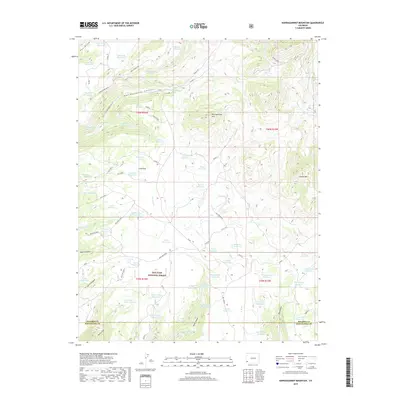
2019 Map of Narraguinnep Mountain
USGS Topo · Published 2019About this map
San Juan National Forest defines the rugged geography of this corner of southwest Colorado, where high ridges and managed watersheds dominate the landscape. The terrain is anchored by notable peaks such as Narraguinnep Mtn and Elston Mtn, with the long stretch of Narraguinnep Ridge and Hosea Ridge framing deep draws and canyons. This 2019 survey documents a complex network of ranching infrastructure and water management, evidenced by the high density of small water bodies like Salter Reservoir, Barney Reservoir, and Young Reservoir. Local names like Glade Ranch and Mccomb Ranch hint at the area's agricultural footprint within the protected forest lands. Tracing the numerous forest roads, such as Glade H and Glade A, reveals a landscape engineered for resource access, connecting natural features like Narraguinnep Spring and Indian Spring to a series of man-made catchments that support the region's ranching economy.
Find a feature on this map
78 named features on this map. Tap any name to fly to it.
Don’t see what you’re looking for? This feature index may not catch every label — zoom into the map to look around manually.
Map Details
Editions of this 2019 Narraguinnep Mountain Map
This is the sole edition of this map. No revisions or reprints were ever made.
Other maps of this area

1956 · Cortez
USGS Topo · 1:250,000

1958 · Cortez
USGS Topo · 1:250,000

1959 · Cortez
USGS Topo · 1:250,000

1962 · Cortez
USGS Topo · 1:250,000

1964 · Glade Mountain
USGS Topo · 1:24,000

1964 · The Glade
USGS Topo · 1:24,000
1964 · South Mountain
USGS Topo · 1:24,000

1965 · Willow Spring
USGS Topo · 1:24,000

1965 · Yellow Jacket
USGS Topo · 1:24,000
1965 · Boggy Draw
USGS Topo · 1:24,000