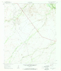
1961 Map of Narrow Bow Draw
USGS Topo · Published 1963About this map
The Pecos River carves through the northeast corner of this West Texas landscape, marking the boundary between Loving Co and Reeves Co. At the start of the 1960s, the terrain was defined by a expanding energy footprint, with the South Orla Oil Field, Regan Oil Field, and Allarmarks Oil Field scattered across the northern and central sections. These industrial developments are interspersed with deep drainage features like Horsehead Draw and Fourmile Draw, while the Panhandle and Santa Fe railroad skirts the riverbank, providing a critical transport link for the region's resources.
Find a feature on this map
14 named features on this map. Tap any name to fly to it.
Don’t see what you’re looking for? This feature index may not catch every label — zoom into the map to look around manually.
Map Details
Editions of this 1961 Narrow Bow Draw Map
2 editions found
Other maps of this area

1931 · Orla
USGS Topo · 1:62,500

1954 · Pecos
USGS Topo · 1:250,000

1957 · Pecos
USGS Topo · 1:250,000

1961 · Anderson Ranch
USGS Topo · 1:24,000

1961 · Orla SE
USGS Topo · 1:24,000

1961 · Lindley Ranch
USGS Topo · 1:24,000

1961 · Narrow Bow Draw
USGS Topo · 1:24,000

1968 · Threemile Draw
USGS Topo · 1:24,000

1968 · Orla
USGS Topo · 1:24,000

1968 · W T Ranch
USGS Topo · 1:24,000