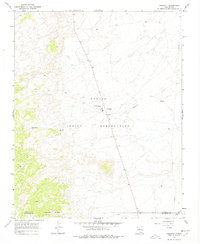
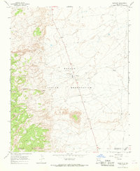
1966 Map of Naschitti
USGS Topo · Published 1978About this map
Navajo Indian Reservation lands dominate this mid-century survey, centered on the settlement of Naschitti. The landscape is defined by the ephemeral drainage of Naschitti Wash, which cuts across a high-desert environment marked by scattered wells and specialized infrastructure like the Sewage Disposal Ponds. The map captures a moment of modern development within the reservation, showing a prominent pipeline and the local road network that connects this community to the broader region of Northwest New Mexico.
Find a feature on this map
11 named features on this map. Tap any name to fly to it.
Don’t see what you’re looking for? This feature index may not catch every label — zoom into the map to look around manually.
Map Details
Editions of this 1966 Naschitti Map
2 editions found
Other maps of this area

1886 · Wingate
USGS Topo · 1:250,000

1889 · Chaco
USGS Topo · 1:250,000

1892 · Wingate
USGS Topo · 1:250,000

1892 · Chaco
USGS Topo · 1:250,000

1954 · Shiprock
USGS Topo · 1:250,000

1954 · Gallup
USGS Topo · 1:250,000
1955 · Tohatchi
USGS Topo · 1:62,500

1958 · Gallup
USGS Topo · 1:250,000

1958 · Shiprock
USGS Topo · 1:250,000

1959 · Shiprock
USGS Topo · 1:250,000
Featured Places
- Shiprock Agency
- Fort Defiance Agency
- Naschitti, Fort Defiance Agency
- San Juan County, NM
- McKinley County, NM