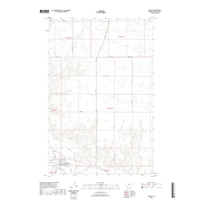
2020 Map of Nashua
USGS Topo · Published 2020About this map
The town of Nashua serves as the focal point of this Valley County landscape, situated near the confluence of several critical waterways. The terrain is defined by the winding course of the Milk River and Porcupine Cr, which are joined by the Porcupine Cr Overflow as they move through the southern portion of the quadrangle. North of the settlement, the geography transitions into a series of drainages, including the elongated Ivy Coulee. This 2020 survey illustrates a rural infrastructure centered on the town, where local life is anchored by the Nashua Cem and a network of named roads like Nashua Blvd and Front St. The presence of the Roosevelt Trl suggests the historical importance of this corridor for regional travel, while secondary routes like Dead Lamb Rd and Bauer Rd provide access to the surrounding agricultural sections.
Find a feature on this map
28 named features on this map. Tap any name to fly to it.
Don’t see what you’re looking for? This feature index may not catch every label — zoom into the map to look around manually.
Map Details
Editions of this 2020 Nashua Map
This is the sole edition of this map. No revisions or reprints were ever made.
Other maps of this area

1914 · Nashua
USGS Topo · 1:62,500

1915 · Frazer
USGS Topo · 1:62,500

1915 · Spring Creek
USGS Topo · 1:62,500

1916 · Nashua
USGS Topo · 1:62,500

1918 · Porcupine Valley
USGS Topo · 1:62,500

1954 · Glasgow
USGS Topo · 1:250,000

1957 · Glasgow
USGS Topo · 1:250,000

1958 · Glasgow
USGS Topo · 1:250,000
1972 · Milk River Coulee
USGS Topo · 1:24,000
1972 · Milk River Hills
USGS Topo · 1:24,000