
1914 Map of Nashua
USGS Topo · Published 1965About this map
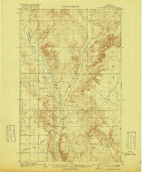
The confluence of the Missouri River and the Milk River anchors this 1914 survey of Valley County, Montana. Settlement is concentrated along the northern rail corridor, where the Nashua townsite sits at the bend of the Great Northern railroad. The landscape is dotted with rural educational institutions serving a burgeoning ranching community, including the Panton School, South Nashua School, Stevens Point School, and Galpin School.
Find a feature on this map
18 named features on this map. Tap any name to fly to it.
Don’t see what you’re looking for? This feature index may not catch every label — zoom into the map to look around manually.
Map Details
Editions of this 1914 Nashua Map
This is the sole edition of this map. No revisions or reprints were ever made.
Other maps of this area

1915 · Frazer
USGS Topo · 1:62,500

1915 · Spring Creek
USGS Topo · 1:62,500

1916 · Nashua
USGS Topo · 1:62,500
1918 · Porcupine Valley
USGS Topo · 1:62,500

1943 · Glasgow
USGS Topo · 1:125,000

1954 · Jordan
USGS Topo · 1:250,000

1954 · Glasgow
USGS Topo · 1:250,000

1956 · Jordan
USGS Topo · 1:250,000

1957 · Glasgow
USGS Topo · 1:250,000

1958 · Glasgow
USGS Topo · 1:250,000