Loading...
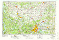
Loading map...1956 Map of Nashville
USGS Topo · Published 1977About this map
Nashville and its surrounding Middle Tennessee and Southern Kentucky landscapes are defined by the winding course of the Cumberland River and a massive expansion of regional water infrastructure. This 1960s-era revision shows the full footprint of Kentucky Lake and Lake Barkley on the western edge, flanking the Tennessee Ridge. To the east, Old Hickory Lake and the Barren River Lake reflect the post-war engineering that reshaped the Cumberland and Barren River basins.
Find a feature on this map
103 named features on this map. Tap any name to fly to it.
Don’t see what you’re looking for? This feature index may not catch every label — zoom into the map to look around manually.
Map Details
Date Portrayed1956
Date Published1977
PublisherU.S. Geological Survey
Map TypeTopographic
Scale1:250,000
Physical Dimensions32.1 x 22.1 inches
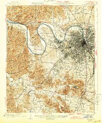
Editions of this 1956 Nashville Map
2 editions found

Historical Maps of Nashville Through Time
4 maps found


Featured Locations
Source Details
SourceU.S. Geological Survey
CopyrightPublic Domain