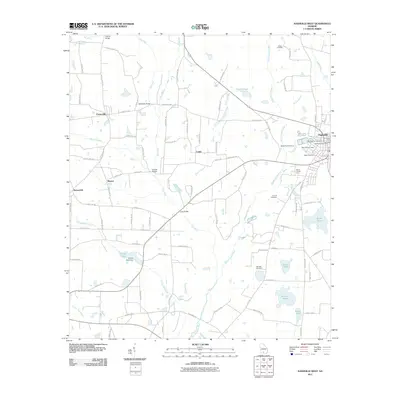
2011 Map of Nashville West
USGS Topo · Published 2011About this map
The Withlacoochee River and New River define the agricultural landscape of Berrien County, where small settlements like Chaserville, Cottle, and Massee are connected by a network of county roads. The eastern edge of the map shows the outskirts of Nashville, including the Nashville Post Office and the Berrien County Farm. This 2011 survey is particularly rich for genealogical research, documenting several family and community burial grounds including the Old Nashville Cemetery, West View Cemetery, and Tygart Cemetery. The terrain is characterized by numerous named water bodies and drainage basins such as Wolf Branch, Youngs Mill Creek, and District Branch. Several historic crossing points remain identified, notably Gainey Bridge, Buckholts Bridge, and Connell Bridge, which reflect the long-standing transportation patterns established before the modern highway system fully bypassed these rural corridors.
Find a feature on this map
95 named features on this map. Tap any name to fly to it.
Don’t see what you’re looking for? This feature index may not catch every label — zoom into the map to look around manually.
Map Details
Editions of this 2011 Nashville West Map
This is the sole edition of this map. No revisions or reprints were ever made.
Other maps of this area

1953 · Waycross
USGS Topo · 1:250,000

1958 · Waycross
USGS Topo · 1:250,000

1972 · Tenmile Bay
USGS Topo · 1:24,000

1973 · Adel
USGS Topo · 1:24,000

1973 · New Lois
USGS Topo · 1:24,000

1973 · Sapps Lake
USGS Topo · 1:24,000

1973 · Cecil
USGS Topo · 1:24,000

1973 · Nashville West
USGS Topo · 1:24,000

1973 · Lenox
USGS Topo · 1:24,000
1978 · Nashville East
USGS Topo · 1:24,000