
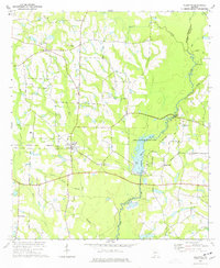
1973 Map of Adel
USGS Topo · Published 1975About this map
The Georgia Southern and Florida railroad corridor defines the development of central Cook County, linking the growing municipality of Adel with the town of Sparks. This early 1970s survey captures a landscape where agriculture and emerging infrastructure coexist, from the Cook County Airport to several municipal sewage disposal systems. The local economy is traced through numerous water features and mills, including Giddens Mill Creek and Halls Pond, while the rural character is preserved in the small settlements of Barneyville and Laconte.
Find a feature on this map
47 named features on this map. Tap any name to fly to it.
Don’t see what you’re looking for? This feature index may not catch every label — zoom into the map to look around manually.
Map Details
Editions of this 1973 Adel Map
This is the sole edition of this map. No revisions or reprints were ever made.
Other maps of this area

1953 · Waycross
USGS Topo · 1:250,000

1958 · Waycross
USGS Topo · 1:250,000

1973 · New Lois
USGS Topo · 1:24,000

1973 · Sapps Lake
USGS Topo · 1:24,000

1973 · Cecil
USGS Topo · 1:24,000

1973 · Nashville West
USGS Topo · 1:24,000

1973 · Lenox
USGS Topo · 1:24,000

1973 · Omega
USGS Topo · 1:24,000

1974 · Berlin East
USGS Topo · 1:24,000
1974 · Ellenton
USGS Topo · 1:24,000