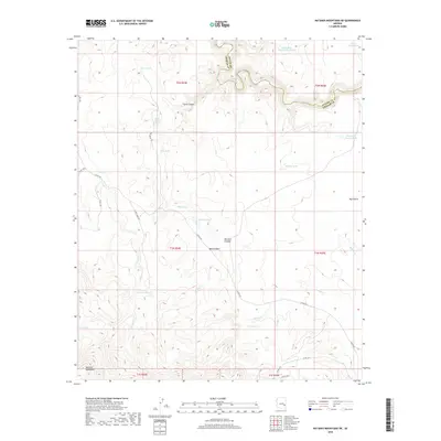
2018 Map of Natanes Mountains NE
USGS Topo · Published 2018About this map
The Black River carves a deep boundary between Apache and Graham counties, anchoring this 2018 survey of high-elevation Arizona wilderness. The landscape is defined by the transition from the Natanes Plateau down toward the winding river valley, featuring a complex network of seasonal water sources and drainages. Essential for land management and cattle ranching in this arid environment, numerous water features such as Stallion Tank, Bobcat Tank, and the Pumping Station Tank are scattered across the terrain.
Find a feature on this map
37 named features on this map. Tap any name to fly to it.
Don’t see what you’re looking for? This feature index may not catch every label — zoom into the map to look around manually.
Map Details
Editions of this 2018 Natanes Mountains NE Map
This is the sole edition of this map. No revisions or reprints were ever made.
Other maps of this area

1954 · Clifton
USGS Topo · 1:250,000

1957 · Clifton
USGS Topo · 1:250,000

1958 · Clifton
USGS Topo · 1:250,000

1962 · Clifton
USGS Topo · 1:250,000
1967 · Sawbuck Mtn.
USGS Topo · 1:24,000
1967 · Maverick SW
USGS Topo · 1:24,000
1967 · West Poker Mtn.
USGS Topo · 1:24,000
1967 · Elwood Canyon
USGS Topo · 1:24,000
1967 · Point of Pines East
USGS Topo · 1:24,000
1967 · Natanes Mts NW
USGS Topo · 1:24,000